 |
Neighborhood Envoy API from eNeighborhoods |
 |
Envoy API is an Internet platform developed and hosted by eNeighborhoods that is integrated directly into your local MLS system. The information is displayed in HTML reports. Envoy API offers providers of MLS systems a highly cost-effective way to integrate demographic, school, and other community information features with the property information features of the MLS systems.
Envoy API Information Categories:
 Schools Schools
Demographics
Employment
Housing
Climate
Houses of Worship
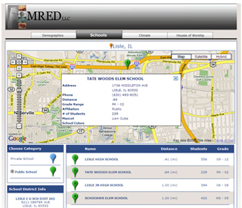
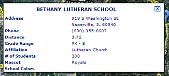
School Information
Public School information is compiled and statistically modeled from the annual school reports submitted by every school district, as required by each state's Department of Education. In most states, these are broken down into multiple reports, representing different topics, which are submitted at different times during the year. The individual data delivered always represents information compiled for a school year, usually September through August of the following calendar year. In many areas of the nation, multiple school districts are common and usually relate to an "elementary" district and a "secondary" district.
The eNeighborhoods Education Index™ shows the education index score for the school district as ranked against every other school district in the nation based upon ten different criteria:
1. Student/teacher ratio
2. Expenditures per student,
3. Percentage of expenditures utilized for Instructional expenses,
4. High School dropout rate,
5. Parent education levels,
6. Percentage of children attending private schools,
7. Student/librarian ratio,
8. Secondary student/guidance counselor ratio,
9. Income level of families with children,
10. Percentage of children living under the poverty level).
The State and National Rankings for the school district, based upon the index, are also delivered in Envoy API. The higher the index score, the better the ranking for the school district. The eNeighborhoods Education Index™, a proprietary product of eNeighborhoods LLC, was developed in conjunction with educational experts. Although it can be used to make general comparisons between school systems, it does not measure all of the characteristics, performance levels and personalities of every school system. The percentile rankings are only meant to rank the eNeighborhoods Education Index™ score and not necessarily the quality of the school district.
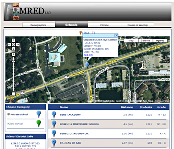
Because information submitted by private schools to state Departments of Education are considered confidential information, the information available is less comprehensive than the information available for public schools.
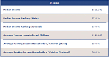
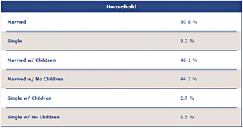
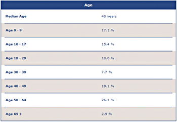
Demographic Information
Demographic information comes from hundreds of government sources, including national, state and local censuses. Demographic Information is delivered for all five geographic entities, except as otherwise noted.
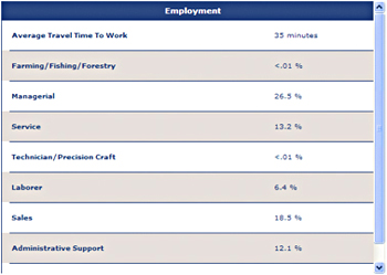
Employment Information
Employment information comes from hundreds of government sources, including national, state and local censuses. Employment Information is delivered for all five geographic entities.
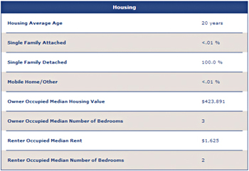
Housing Information
Housing information comes from thousands of government and private sources. These include:
Property records collected at local (typically county) deed/assessment offices,
Real Estate and mortgage company records,
National/State censuses.
Housing Information is delivered for all five geographic levels. Individual home sales data is taken from the actual property deeds. The information delivered is dependent on the figures reported on the deed, which varies from county-to-county and state-to-state. In many areas the sales prices are interpreted from deed recording tax fees/stamps or mortgage amounts, and may be delivered as a value range.
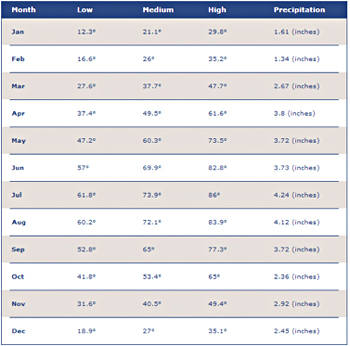
Climate Information
Climate information comes from data captured by the U.S. National Climatic Data Center, which measures climate conditions at nearly ten thousand National Weather Stations nationwide. The information is delivered for the National Weather Station geographically closest to the selected address. For most weather stations, this information is normalized over a 30-year period. Precipitation totals include rainfall and snowfall.
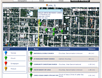
Houses of Worship Information
Houses of Worship information comes from hundreds of private sources, including membership lists, survey compilations and telephone directories.
How Envoy API Information is Displayed
Envoy API displays neighborhood information in five distinct geographic levels. This process allows us to accurately show information for a geographic level as small in size as a neighborhood, instead of relying on less effective level of display like ZIP codes.
Geographic Levels:
Neighborhood
Incorporated Area: City, Town, Village, etc.
Locality/Unincorporated Area
County
State
What is a Neighborhood?
Neighborhood, the smallest Envoy geographic entity, represents Census Tracts as defined by the U.S. Census Bureau. Neighborhoods, or Census Tracts, can vary in size from one place to another and are based on population density. The U.S Census Bureau uses numbers to represent Census Tracts. Since Census Tracts are not given names, Neighborhood facts delivered in Envoy API are named as the "Neighborhood Within …" the named area in which it is located. Neighborhood facts are available when the Census Tract is geographically smaller than the named area in which it is located.
What Is an Incorporated Area?
Incorporated Area represents the geography of an incorporated area’s municipal boundaries. An Incorporated Area is a type of governmental unit, incorporated under state law as a city, city and borough, municipality, town, borough, or village that has legally prescribed limits, powers, and functions.
What Is a Locality/Unincorporated Area?
Locality/Area represents the geography of an unincorporated, but commonly named place, defined by the U.S. Census Bureau as either a CDP (Census Designated Place) or CSC (Census Sub-County). Locality facts are available when the Locality is geographically smaller than the incorporated area in which it is located.
What Is a County?
County is the primary legal division of every state except Alaska and Louisiana. A number of geographic entities are not legally designated as a county, but are recognized by Envoy as equivalent to a County for data presentation purposes. These include the boroughs, city and boroughs, municipality, and census areas in Alaska and parishes in Louisiana. Because it contains no primary legal divisions, Envoy treats the District of Columbia as equivalent to a county (as well as equivalent to a state) for data presentation purposes.
|
|
|
|
|